 05-10-08, 11:52 AM
|
#1 |
|
BassFishin.Com Active Member
Join Date: Jul 2007
Location: Cordell, OK
Posts: 148
 |
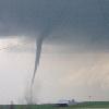
There is a very strong storm system over the Southeast U.S. today. A tornado outbreak is almost certain in this area.
Risk area is from E central OK to central GA and from central MS to Southern IL. Please visit this webpage to see outlook area. -Eric ----------------------------------------------------------------------------------- SPC AC 101210 DAY 1 CONVECTIVE OUTLOOK NWS STORM PREDICTION CENTER NORMAN OK 0710 AM CDT SAT MAY 10 2008 VALID 101300Z - 111200Z ...THERE IS A MDT RISK OF SVR TSTMS ARKLATEX AND MID SOUTH REGION EASTWARD ACROSS THE GULF COAST STATES TODAY AND TONIGHT... ...THERE IS A SLGT RISK OF SVR TSTMS SURROUNDING THE MDT RISK FROM THE SRN PLAINS EWD TO THE ATLANTIC COAST AND NWD TO LOWER OH VALLEY... ....WIDESPREAD SEVERE THUNDERSTORMS INCLUDING TORNADOES EXPECTED FROM THE LOWER MS VALLEY EWD ACROSS GULF STATES AND WRN TN VALLEY... A COMPLEX AND POTENTIALLY DANGEROUS SEVERE WEATHER SITUATION WILL DEVELOP TODAY AS A VIGOROUS UPPER SYSTEM FROM THE ROCKIES AND POWERFUL LATE SPRING UPPER JET LEAD TO A RAPIDLY DEEPENING LOW PRESSURE SYSTEM CENTRAL U.S BEGINNING THIS AFTERNOON. MOIST AND POTENTIALLY VERY UNSTABLE AIRMASS IS IN PLACE FROM ERN TX ACROSS GULF STATES TO THE S OF STALLED FRONTAL ZONE FROM NRN GA TO SRN AR. PRECEEDING THE ROCKIES UPPER TROUGH A MID LEVEL WIND MAX WILL QUICKLY CROSS THE SRN PLAINS AND ENHANCE BOTH LIFT AND SHEAR FOR SEVERE THUNDERSTORM DEVELOPMENT BY EARLY AFTERNOON VICINITY WRN PORTION OF STALLED FRONTAL ZONE. WITH AN ELEVATED MIXED LAYER IN PLACE ACROSS THE WARM SECTOR AND STRONG HEATING...MLCAPES WILL RAPIDLY CLIMB TO ABOVE 2500 J/KG. BY MID AFTERNOON MUCH OF THE WARM SECTOR S OF FRONT WILL BE RIPE FOR THUNDERSTORM DEVELOPMENT. SUPERCELLS INCLUDING BOTH TORNADOES AND LARGE HAIL WILL BE MOST LIKELY AHEAD OF THE WIND MAX VICINITY FRONTAL ZONE SRN AR. 60-70KT OF DEEP LAYER SHEAR COUPLED WITH THE INSTABILITY WILL CREATE CONDITIONS FAVORABLE FOR LONG LIVED SUPERCELLS INCLUDING THREAT OF STRONG TORNADOES. ORGANIZED STORMS/SUPERCELLS WILL MOVE RAPIDLY EWD UNDER THE STRONG JET MAX ACROSS MS/AL TO GA TONIGHT. THIS COMPLEX COULD EVOLVE INTO A DERECHO TYPE SYSTEM WITH AN ENHANCED WIND DAMAGE POTENTIAL. ADDITIONAL SEVERE STORMS ARE LIKELY IN ADVANCE OF THE MORE ORGANIZED THREAT ACROSS THE INTERIOR GULF STATES THIS AFTERNOON GIVEN THE AVAILABLE SHEAR/INSTABILITY IN PLACE. AS THE SURFACE LOW BEGINS THE DEEPENING PROCESS OVER ERN KS THIS AFTERNOON...LOW LEVEL MOISTURE WILL RAPIDLY SPREAD NEWD ACROSS LOWER MO INTO LOWER OH VALLEYS. SEVERE THUNDERSTORMS WILL INITIALLY DEVELOP AHEAD OF THE SURFACE LOW AND ALONG THE COLD FRONT EXPENDING SWD INTO ERN OK/NRN TX. VERY IMPRESSIVE DEEPENING OF THE SURFACE AND UPPER LOW FORECASTED TONIGHT EXPECTED TO LEAD TO AT LEAST A FORCED SQUALL LINE OF DAMAGING WINDS AND EMBEDDED SUPERCELLS THAT WILL TRACK ACROSS THE LOWER MO VALLEY INTO MID MS VALLEY OVERNIGHT. THE TORNADO POTENTIAL THIS AREA WILL BE DEPENDENT ON AMOUNT OF DESTABILIZATION THAT CAN OCCUR AND HOW FAR N. GFS IS INDICATING THERE WILL BE SUFFICIENT INSTABILITY FOR BOTH VERY DAMAGING WINDS AND TORNADIC SUPERCELLS AS THE SQUALL LINE MOVES RAPIDLY EWD DRIVEN BY THE 100KT 500MB WIND MAX ROTATING AROUND THE DEEPENING LOW ACROSS NRN MO. HAVE SHIFTED BOTH THE MDT/SLGT RISK AREAS SIGNIFICANTLY NWD TO ACCOUNT FOR THE EXPECTED GREATER INSTABILITY. ALONG WITH THE TORNADO POTENTIAL...SIGNIFICANT WIND DAMAGE WILL ACCOMPANY THE SQUALL LINE POSSIBLY AS FAR E AS LOWER OH AND WRN TN VALLEYS LATER TONIGHT. GIVEN THE COMPLEXITY/INTENSITY OF THE DEVELOPING STORM SYSTEM AND AVAILABILITY OF UNSTABLE GULF AIR...THE NEXT 24-48 HOURS EXPECTED TO SEE A LARGE AREA AFFECTED BY SEVERE THUNDERSTORMS INCLUDING THE POTENTIAL FOR STRONG TORNADOES AND PARTICULARLY DAMAGING WINDS. ..HALES/JEWELL.. 05/10/2008 CLICK TO GET WUUS01 PTSDY1 PRODUCT NOTE: THE NEXT DAY 1 OUTLOOK IS SCHEDULED BY 1630Z
__________________
Spring time storm chaser, Year round Bass Angler!!! Largest bass; 6lbs 1oz., Length: 22" Girth: 15" |

|

|
|
05-10-08, 12:08 PM
|
#2 |
|
BassFishin.Com Premier Elite

Join Date: Dec 2001
Location: Huntsville, Al
Posts: 7,466
|
Unfortunatly I live in a terrible area to chase storms. Looks like we'll have them today.
__________________
Selling live waterdogs for less since 2005. |
|
|
|
|
05-10-08, 01:35 PM
|
#3 |
|
BassFishin.Com Active Member
Join Date: Jul 2007
Location: Cordell, OK
Posts: 148
|
Well, If I lived in your area I would do it anyways but, things will be too far off for me and my pocketbook to handle it today.
 Every one be careful and keep an eye on the sky today. Especially overnight in the SE. -Eric
__________________
Spring time storm chaser, Year round Bass Angler!!! Largest bass; 6lbs 1oz., Length: 22" Girth: 15" |
|
|
|
|
05-10-08, 02:17 PM
|
#4 |
|
BassFishin.Com Premier Elite
Join Date: Dec 2001
Location: Huntsville, Al
Posts: 7,466
|
The roads around here make it tricky, and with all the trees and hills you can't see that well is your problem. There are some, but they normally don't get good shots.
__________________
Selling live waterdogs for less since 2005. |
|
|
|
|
05-10-08, 02:35 PM
|
#5 |
|
BassFishin.Com Active Member
Join Date: Jul 2007
Location: Cordell, OK
Posts: 148
|
I've chased SE Oklahoma so I know exactly what your talking about. It's a real pain in the a$$ but, it's possible. Though, It's unlikely I'll chase down there again anytime soon. I prefer to stay W of I-35.
-Eric
__________________
Spring time storm chaser, Year round Bass Angler!!! Largest bass; 6lbs 1oz., Length: 22" Girth: 15" |
|
|
|
|
05-10-08, 04:56 PM
|
#6 |
|
BassFishin.Com Premier Elite

Join Date: Jan 2008
Location: cedar bluff, alabama
Posts: 15,292
|
had tornados last week, quarter sized hail last night, right here at my house.
|
|
|
|
|
05-11-08, 01:40 AM
|
#7 |
|
BassFishin.Com Active Member
Join Date: Jul 2007
Location: Cordell, OK
Posts: 148
|
SPC now confirming 34 tornadoes and 19 fatalities thus far. These are only prelimenary reports so please keep these victims and their families in your prayers.
Tornadic storms are still ongoing across MS and AL. Storms will progressively move E into TN, GA, and the Carolinas overnight. Everyone in these areas stay weather alert. -Eric
__________________
Spring time storm chaser, Year round Bass Angler!!! Largest bass; 6lbs 1oz., Length: 22" Girth: 15" |
|
|
|
|
05-11-08, 09:08 PM
|
#8 |
|
BassFishin.Com Veteran Member

Join Date: Aug 2005
Location: Richmond, Virginia
Posts: 805
|
We just had a storm system move by a couple hours ago. Had tornado warning all over the place. This has been very unusual for around here to have so many tornado warnings.
Eric, I was in the Air National Guard for 14 years as a weather forecaster. Spent some time in Illinois but never got to really do the storm chasing thing. Had a EF0 find my house though a few weeks ago. Glad it was a 0 and not something much worse. That was enough for me!!! 
__________________
Eric |
|
|
|
|
05-11-08, 09:10 PM
|
#9 |
|
BassFishin.Com Premier Elite
Join Date: Dec 2001
Location: Huntsville, Al
Posts: 7,466
|
We had a ton of warnings to the north of us yesterday. There was at one point a line of 6 or seven counties with warnings. For whatever reason it seems like there has been a lot of windshear whenever we have an outbreak.
__________________
Selling live waterdogs for less since 2005. |
|
|
|
|
05-11-08, 10:56 PM
|
#10 |
|
BassFishin.Com Premier Elite
Join Date: Jan 2008
Location: cedar bluff, alabama
Posts: 15,292
|
wtl we were in that storm buddy. and here i thought that we would be safe, safer than the hurricanes, lol. gonna buid a storm shelter when we get moved for SURE.
|
|
|
|
|
05-12-08, 02:23 AM
|
#11 | |
|
BassFishin.Com Active Member
Join Date: Jul 2007
Location: Cordell, OK
Posts: 148
|
Quote:
-Eric
__________________
Spring time storm chaser, Year round Bass Angler!!! Largest bass; 6lbs 1oz., Length: 22" Girth: 15" |
|
|
|
|
|
05-12-08, 04:53 AM
|
#12 |
|
BassFishin.Com Premier Elite
Join Date: Dec 2001
Location: Huntsville, Al
Posts: 7,466
|
Thats just how things go, every few years or so weather gets into a pattern - it can be the mississippi river floods of 93 or the hurricanes of 05 or this year and tornadoes. I remember in 05 I watched a couple early season storms strenghten very quickly in the gulf and took note that for whatever reason storms were blowing up there - then Katrina formed on the east coast of Florida and as it passed over that state meterologists were saying it would make landfall in the gulfcoast as a 2 on the saffir simpson, and I was like "hey guys, I don't know, since last year with charlie every hurricane in that part of the gulf has blown up". Sure enough that year had 3 of the most powerful atlantic storms ever observed in Katrina, Rita and Wilma all right in the gulf of mexico. A lot of people want to blame that sorta thing on El Nino, La Nina, global warming, space aliens or whatever else - and while it can be tempting to do that its probably lazy science - all I know is sometimes luck turns and you get into a bad season where you better be on a huge lookout.
__________________
Selling live waterdogs for less since 2005. |
|
|
|
|
05-13-08, 07:12 AM
|
#13 |
|
BassFishin.Com Active Member
Join Date: Jul 2007
Location: Cordell, OK
Posts: 148
|
All reports have been counted from the 5/10/08 Tornado Outbreak. There were 54 tornadoes, some of which were rated EF-4 on the Enhanced Fugita Scale. These storms have taken the lives of 21 people and injured dozens of others. Please keep the victims and their families in your prayers.
All reports can be seen Here. -Eric
__________________
Spring time storm chaser, Year round Bass Angler!!! Largest bass; 6lbs 1oz., Length: 22" Girth: 15" |
|
|
|
 |
|
Disclosure / Disclaimer
Before acting on the content posted, you should know that BassFishin.Com may benefit financially and otherwise from content, advertising, links or otherwise from anything you click on, read, or look at on our website. Click here to read our Disclosure Policy and Disclaimer. |
| Currently Active Users Viewing This Thread: 1 (0 members and 1 guests) | |
|
|


 Linear Mode

