 03-29-08, 03:53 AM
|
#1 |
|
BassFishin.Com Active Member

Join Date: Jul 2007
Location: Cordell, OK
Posts: 148
 |
A possible tornado outbreak is expected over western and central Oklahoma and southern Kansas on 3/30/08. Isolated tornadoes are also possible, but unlikely, over northern Missouri.
Below is the SPC convective outlook for Sunday. I will update this thread as more information is available. -Eric ----------------------------------------------------------------------------------- SPC AC 290558 DAY 2 CONVECTIVE OUTLOOK NWS STORM PREDICTION CENTER NORMAN OK 1258 AM CDT SAT MAR 29 2008 VALID 301200Z - 311200Z ...THERE IS A SLGT RISK OF SVR TSTMS ACROSS THE SRN PLAINS...CNTRL PLAINS AND MID MO VALLEY... ...SRN PLAINS/CNTRL PLAINS/MID MO VALLEY... MODEL FORECASTS CONTINUE WITH A PROGRESSIVE WRN US UPPER-LEVEL TROUGH SATURDAY NIGHT INTO SUNDAY WITH A BROAD BAND OF SOUTHWEST FLOW OVER THE CNTRL STATES. IN RESPONSE...A LOW-LEVEL JET WILL STRENGTHEN SUNDAY AND SUNDAY NIGHT ACROSS THE SRN AND CNTRL PLAINS INCREASING BOUNDARY LAYER MOISTURE FROM NORTH TO SOUTH. AT THE SFC...CONFIDENCE IS INCREASING CONCERNING THE POSITION OF A STATIONARY FRONT WHICH SHOULD BE LOCATED FROM NRN OK ENEWD ACROSS SE KS INTO NRN MO BY LATE AFTERNOON SUNDAY. A STRONG CAPPING INVERSION SHOULD KEEP SURFACE-BASED CONVECTION FROM DEVELOPING IN THE AFTERNOON. HOWEVER...THE CAP IS FORECAST TO WEAKEN BY EARLY EVENING AND SEVERAL AREAS OF DEEP CONVECTION SHOULD INITIATE ALONG THE BOUNDARY WITH AN INCREASE IN CONVECTIVE COVERAGE DURING THE EVENING AND OVERNIGHT PERIOD. MCS DEVELOPMENT WILL BE POSSIBLE ACROSS PARTS OF THE PLAINS OR MID MS VALLEY REGIONS SUNDAY NIGHT. THE SYNOPTIC PATTERN FOR THE LATER HALF OF THE DAY 2 PERIOD APPEARS FAVORABLE FOR A SIGNIFICANT SEVERE WEATHER EVENT ACROSS THE NRN PART OF THE SRN PLAINS. MODEL FORECASTS CONTINUE TO DEVELOP A LARGE AREA OF MODERATE INSTABILITY WITH INCREASING INFLUENCE OF THE UPPER-LEVEL TROUGH TO THE WEST. THIS COMBINED WITH A STEADILY INCREASING LOW-LEVEL JET DURING THE EVENING AND INCREASING LOW-LEVEL MOISTURE SHOULD RESULT IN A FAVORABLE THERMODYNAMIC AND SHEAR ENVIRONMENT FOR PERSISTENT SUPERCELLS CAPABLE OF PRODUCING TORNADOES. A FEW STRONG AND/OR LONG-LIVED TORNADOES COULD OCCUR WITH PERSISTENT SUPERCELLS THAT MOVE PARALLEL TO THE BOUNDARY. THE CORRIDOR FOR SIGNIFICANT SEVERE WEATHER APPEARS MOST LIKELY TO SET UP FROM WRN AND CNTRL OK NEWD INTO SE KS WITH THE THREAT INCREASING DURING THE EVENING AND PERSISTENT INTO THE OVERNIGHT PERIOD. FURTHER NEWD ACROSS WRN AND NRN MO...LARGE-SCALE ASCENT AND LOW-LEVEL MOISTURE WILL BE LESS DUE TO A LOCATION FURTHER AWAY FROM THE WRN US UPPER-LEVEL TROUGH. AS THE LOW-LEVEL JET STRENGTHENS ACROSS THE REGION DURING THE EVENING...STRONG LIFT ALONG THE JET AXIS SHOULD RESULT IN THE DEVELOPMENT OF ELEVATED STORMS. MODERATE VERTICAL SHEAR AND COLD MID-LEVEL TEMPS EVIDENT ON FORECAST SOUNDINGS SUGGEST A SEVERE CONVECTIVE CLUSTER SHOULD DEVELOP DURING THE EVENING AND OVERNIGHT PERIOD. ..BROYLES.. 03/29/2008 ----------------------------------------------------------------------------------- Follow this link for graphical information. It is currently on day two. Also, check your local NWS homepage. http://www.weather.gov/ Click your location on the map for info.
__________________
Spring time storm chaser, Year round Bass Angler!!! Largest bass; 6lbs 1oz., Length: 22" Girth: 15" |

|

|
|
03-29-08, 05:20 AM
|
#2 |
|
BassFishin.Com Premier Elite

Join Date: Jan 2004
Location: denton nc
Posts: 13,441
|
and jackl sent me and e-mail last night about being on amistad this weekend..go figure...
zooker
__________________
the godfather.. aml in remission since 7-20-09 |
|
|
|
|
03-29-08, 11:47 AM
|
#3 |
|
BassFishin.Com Premier Elite

Join Date: Jun 2003
Location: San Antonio, TX
Posts: 10,142
|
Amistad? 2 hours west-maybe we'll get lucky-we really need rain, but not tornados.
"I'm happier than a tornado in a trailer park!!!!" 
__________________
It's happened to the best of them: John 21:3 Last edited by Rebbasser; 03-29-08 at 11:53 AM. |
|
|
|
|
03-29-08, 12:29 PM
|
#4 |
|
BassFishin.Com Active Member
Join Date: Jul 2007
Location: Cordell, OK
Posts: 148
|
The next SPC outlook will be posted at 1730Z (12:30 CST). I have gone over the latest models and will post their's and my forecast after SPC has updated it's day 2 covective outlook. I will say that this is shaping up to be a VERY DANGEROUS night-time event over W. Oklahoma. Everyone in this area needs to monitor this closely for rapidly changing weather during the overnight hours on Sunday/Monday morning.
-Eric
__________________
Spring time storm chaser, Year round Bass Angler!!! Largest bass; 6lbs 1oz., Length: 22" Girth: 15" |
|
|
|
|
03-29-08, 02:26 PM
|
#5 |
|
BassFishin.Com Active Member
Join Date: Jul 2007
Location: Cordell, OK
Posts: 148
|
First is SPC,
----------------------------------------------------------------------- SPC AC 291725 DAY 2 CONVECTIVE OUTLOOK NWS STORM PREDICTION CENTER NORMAN OK 1225 PM CDT SAT MAR 29 2008 VALID 301200Z - 311200Z ...THERE IS A SLGT RISK OF SVR TSTMS FROM WRN OK AND VICINITY NEWD INTO NRN MO AND ADJACENT AREAS... ...SYNOPSIS... PROGRESSIVE/AMPLIFYING UPPER PATTERN IS ANTICIPATED DAY 2...AS LARGE UPPER TROUGH OVER THE WRN U.S. DIGS/MOVES SLOWLY EWD ACROSS THE ROCKIES/TOWARD THE PLAINS THROUGH THE PERIOD. AT THE SURFACE...SLY FLOW IS FORECAST ACROSS THE S CENTRAL CONUS AND INTO THE MID MS VALLEY REGION...S OF A BAROCLINIC ZONE EXPECTED TO EXTEND FROM THE TX/OK PANHANDLES/SRN KS EWD ACROSS MO INTO IL. ALONG THIS BOUNDARY...A LEE LOW IS EXPECTED TO PERSIST...WHICH SHOULD EVENTUALLY SHIFT ENEWD ALONG THE BOUNDARY ACROSS NRN OK AND INTO ERN KS BY THE END OF THE PERIOD. ...PARTS OF OK/ERN KS/MO AND VICINITY... A WARMING/MOISTENING BOUNDARY LAYER IS FORECAST THROUGH THE FIRST HALF OF THE PERIOD...AS PERSISTENT SLY FLOW PREVAILS ACROSS THE S CENTRAL CONUS AHEAD OF WRN UPPER TROUGH. WHILE STEEP LAPSE RATES ASSOCIATED WITH AN ELEVATED MIXED LAYER WILL ALSO CONTINUE TO OVERSPREAD THIS REGION FROM THE W/SW...ASSOCIATED CAPPING INVERSION SHOULD SUPPRESS ANY WARM SECTOR STORM DEVELOPMENT THROUGH MOST OF THE AFTERNOON. BY LATE AFTERNOON/EARLY EVENING...A FEW ISOLATED STORMS MAY DEVELOP ACROSS ERN PORTIONS OF THE TX/OK PANHANDLES OR ADJACENT WRN OK...WHERE DEWPOINTS IN THE 60S BENEATH STEEP LAPSE RATES ALOFT SHOULD RESULT IN MODERATE INSTABILITY /1500 TO 2000 J/KG MIXED-LAYER CAPE/. MORE WIDESPREAD DEVELOPMENT IS EXPECTED LATER IN THE EVENING NEAR AND N OF SURFACE BOUNDARY...AS LOW-LEVEL JET INTENSIFIES. THIS DEVELOPMENT SHOULD BE PRIMARILY DRIVEN BY INCREASING LOW-LEVEL WARM ADVECTION IN CONJUNCTION WITH THE ONSET OF MID-LEVEL HEIGHT FALLS AHEAD OF THE APPROACHING TROUGH. WITH MODERATE /NEAR 40 KT/ WSWLY MID-LEVEL FLOW FORECAST TO PERSIST FROM AFTERNOON ONWARD...INCREASINGLY-FAVORABLE DEEP-LAYER SHEAR FOR SUPERCELLS IS FORECAST AS SSWLY LOW-LEVEL JET INCREASES THROUGH THE AFTERNOON -- AND PARTICULARLY AFTER SUNSET. GIVEN DEGREE OF INSTABILITY EXPECTED...LARGE HAIL WILL BE LIKELY -- PARTICULARLY WITHIN A ZONE FROM SWRN OK NEWD ACROSS S CENTRAL AND SERN KS. LOCALLY-DAMAGING WINDS WILL ALSO BE POSSIBLE...AS WILL A FEW TORNADOES -- PARTICULARLY DURING THE EVENING AS LOW-LEVEL JET STRENGTHENS INCREASING THE DEGREE OF LOW-LEVEL SHEAR. SEVERE THREAT IS EXPECTED TO SPREAD NEWD OVERNIGHT IN CONJUNCTION WITH STRENGTHENING LOW-LEVEL JET AND A NEWD SHIFT OF THE STRONGER WARM ADVECTION INTO THE MIDDLE MO VALLEY REGION. WITH A TENDENCY FOR MORE ELEVATED CONVECTION WITH NEWD EXTENT...PRIMARY THREAT ACROSS THIS REGION SHOULD BE HAIL. ..GOSS.. 03/29/2008 CLICK TO GET WUUS02 PTSDY2 PRODUCT NOTE: THE NEXT DAY 2 OUTLOOK IS SCHEDULED BY 0800Z CURRENT UTC TIME: 1740Z (12:40PM), RELOAD THIS PAGE TO UPDATE THE TIME ----------------------------------------------------------------------- My forecast is accually fairly close to SPC's, although I think the tornado threat will be a little higher. SE Kansas and MO you can now breathe again  but, W., N. Oklahoma and SC Kansas watch out. but, W., N. Oklahoma and SC Kansas watch out.Early Convection in KS an MO: Storms should develope along the cold front from SC Kansas to possibly as far as C. MO in the mid afternoon hours with the main threat being hail and high winds. Tornadoes with this early convection are very unlikely but cannot be ruled out at this time. If you live in this area and have outdoor plans, just be sure to bring an umbrella. Late Afternoon and Evening Convection in OK and KS: Isolated Supercells are forecast to develope along the cold front and associated dryline in NW Oklahoma near the low. Any storms that develope in this area will quickly become severe. Early on a capping inversion should limit storm coverage (hence the slight risk) but, as the short-wave trough pushes into the area the cap will weaken and storms will increase in coverage during the evening/overnight hours. Shear will also strengthen during this time period posing a greater threat for large hail and tornadoes. Some strong/long tracked tornadoes can't be ruled out at the present time. OK, KS Tornado Threat Discussion: Despite concerns regarding the cap, I don't think this will largely inhibit late afternoon/evening convection over NW and WC Oklahoma. First, There is increasing flow over the rockies which normally is attributed to local outbreak events. Second, The upper-flow could very well strengthen more than progged at this early stage. (This is what happened on May 3, 1999.) Third, there is a very strong moisture advection which is doing wonders for the CAPE (CAPE means Convective Available and Potential Energy, I think ). All in all this could turn out to be a decent setup.Storm Speed and Direction: ENE at 20-25mph Severe Risk: Slight (15-30% chance of a severe thunderstorm within 25 miles of any given point in the risk area) Primary Concerns: Large Hail, Damaging Winds, and Tornadoes Links: http://spc.noaa.gov/ http://spc.noaa.gov/products/outlook/ http://www.weather.gov/ http://www.srh.noaa.gov/oun/enhanced.php http://weather.cod.edu/ http://www.wxcaster.com/weather.php3 People in the NW half of Oklahoma and SC Kansas, monitor weather situation closely sunday (3/30/08) evening and during the overnight periods. -Eric
__________________
Spring time storm chaser, Year round Bass Angler!!! Largest bass; 6lbs 1oz., Length: 22" Girth: 15" |
|
|
|
|
03-30-08, 08:53 AM
|
#6 |
|
BassFishin.Com Premier Elite

Join Date: Jan 2008
Location: cedar bluff, alabama
Posts: 15,292
|
hope ya'll take cover out there guys! hope no one gets hurt. good luck.
|
|
|
|
|
03-30-08, 11:07 AM
|
#7 |
|
BassFishin.Com Active Member
Join Date: Jul 2007
Location: Cordell, OK
Posts: 148
|
New SPC Day 1 Convective Outlook:
SPC AC 301244 DAY 1 CONVECTIVE OUTLOOK NWS STORM PREDICTION CENTER NORMAN OK 0744 AM CDT SUN MAR 30 2008 VALID 301300Z - 311200Z ...THERE IS A SLGT RISK OF SVR TSTMS TODAY FROM E TX INTO LA... ...THERE IS A SLGT RISK OF SVR TSTMS THIS EVENING INTO TONIGHT FROM NW OK TO THE NE KS/NW MO AREA... ...NW OK/SW KS LATE THIS EVENING... A SURFACE COLD FRONT WILL CONTINUE TO DRIFT SWD ACROSS KS IN THE WAKE OF A STRONG MID LEVEL TROUGH EJECTING NEWD OVER WRN ONTARIO. S OF THIS BOUNDARY...A MOIST LOW-LEVEL AIR MASS /BOUNDARY LAYER DEWPOINTS OF 64-68 F/ WILL SPREAD NWD ACROSS TX/OK/SRN KS DURING THE DAY. LOW CLOUDS MAY SLOW SURFACE HEATING WITHIN THE MOIST AIR MASS...BUT STRONGER SURFACE HEATING ALONG A DEVELOPING DRYLINE NEAR THE WRN OK/TX BORDER WILL COMBINE WITH THE INCREASING MOISTURE AND STEEP MID LEVEL LAPSE RATES TO SUPPORT MLCAPE VALUES OF 1500-2500 J/KG THIS AFTERNOON/EVENING ACROSS NW TX AND CENTRAL/WRN OK. THE PRIMARY UNCERTAINTY FOR THIS AREA WILL BE WHETHER OR NOT SURFACE-BASED CONVECTIVE INITIATION WILL OCCUR BY THIS EVENING. WATER VAPOR IMAGERY SHOWS A WEAK LEAD SHORTWAVE TROUGH OVER THE LOWER CO RIVER VALLEY THAT EXTRAPOLATES TO THE WRN KS VICINITY BY LATE THIS EVENING. THIS FEATURE SHOULD BE RELATIVELY DIFFUSE AND CONVECTIVE INITIATION WILL LIKELY RELY ON AFTERNOON TEMPERATURES IN THE LOW-MID 80S TO MINIMIZE CONVECTIVE INHIBITION ALONG THE DRYLINE AND NEAR THE SURFACE TRIPLE POINT...AS WELL AS LOW-LEVEL ASCENT ALONG THE SLOW MOVING FRONT ENE OF THE TRIPLE POINT. IF DEEP CONVECTION CAN DEVELOP PRIOR TO NOCTURNAL STABILIZATION OF THE NEAR-SURFACE LAYER...A PRONOUNCED INCREASE IN THE SLY LLJ AND ASSOCIATED LOW-LEVEL SHEAR FROM 00-03Z WILL CONTRIBUTE TO FAVORABLE VERTICAL SHEAR FOR TORNADIC SUPERCELLS THE FIRST HALF OF TONIGHT. VERY LARGE HAIL WILL BE POSSIBLE WITH ANY SUPERCELLS...AS WELL. ...CENTRAL/NE KS INTO NW MO LATE TONIGHT... THE FRONT WILL LIKELY RETREAT NWD ACROSS NE KS/NW MO LATE TONIGHT IN RESPONSE TO CYCLOGENESIS ACROSS CENTRAL/NE KS...IN ADVANCE OF THE PRIMARY MID LEVEL WAVE /NOW JUST OFF THE CENTRAL CA COAST/ THAT WILL BEGIN TO EMERGE OVER THE HIGH PLAINS FROM 06-12Z. INCREASING LOW-LEVEL WAA ON THE NOSE OF A 40-50 KT LLJ SHOULD SUPPORT ELEVATED THUNDERSTORM DEVELOPMENT OVERNIGHT ALONG AND N OF THE SURFACE BAROCLINIC ZONE. STEEP MID LEVEL LAPSE RATES AND AN INFLUX OF RICH MOISTURE FROM THE S WILL SUPPORT MUCAPE VALUES OF 1500-2000 J/KG OVERNIGHT...AND THE POTENTIAL FOR LARGE HAIL WITH ELEVATED SUPERCELLS. ...E/NE TX AND LA TODAY... A LARGE AREA OF ELEVATED THUNDERSTORMS HAS PERSISTED OVERNIGHT ACROSS AR/MO...WITH RENEWED DEVELOPMENT OVER E/NE TX THE PAST COUPLE OF HOURS. THIS CONVECTION APPEARS TO BE REINFORCING THE BAROCLINIC ZONE FROM NE TX INTO NRN LA/SRN AR AND NW MS. EXPECT ADDITIONAL THUNDERSTORMS TO FORM DURING THE DAY ALONG THE PRIMARY FRONT AND A SECONDARY DIFFUSE MARINE WARM FRONT FROM E TX INTO LA...IN ADVANCE OF A WEAK MID LEVEL SHORTWAVE TROUGH MOVING ENEWD FROM CENTRAL/E TX. RICH LOW-LEVEL MOISTURE AND THE RESIDUAL ERN EXTENT OF THE ELEVATED MIXED LAYER OVER TX/OK WILL SUPPORT MODERATE INSTABILITY AND STRONG UPDRAFTS CAPABLE OF PRODUCING ISOLATED LARGE HAIL. ..THOMPSON/SMITH.. 03/30/2008 CLICK TO GET WUUS01 PTSDY1 PRODUCT NOTE: THE NEXT DAY 1 OUTLOOK IS SCHEDULED BY 1630Z CURRENT UTC TIME: 1455Z (9:55AM), RELOAD THIS PAGE TO UPDATE THE TIME ----------------------------------------------------------------------------------- My original forecast has not changed much although if RUC model guidence verifies, storms could fire along and east of the dryline earlier than expected. RUC convective precipitation has established supercells over western Oklahoma and SC Kansas by 00Z (7pm CST). Any storms that do develope in this region will quickly become severe with the likelyhood of large hail and isolated tornadoes. A few strong/long-tracked tornadoes are also possible. Please monitor the weather during the late afternoon, evening, and overnight hours for rapidly changing conditions. -Eric
__________________
Spring time storm chaser, Year round Bass Angler!!! Largest bass; 6lbs 1oz., Length: 22" Girth: 15" |
|
|
|
|
03-30-08, 11:48 AM
|
#8 |
|
BassFishin.Com Active Member
Join Date: Jul 2007
Location: Cordell, OK
Posts: 148
|
Quick little graphical update.
__________________
Spring time storm chaser, Year round Bass Angler!!! Largest bass; 6lbs 1oz., Length: 22" Girth: 15" |
|
|
|
|
03-30-08, 01:15 PM
|
#9 |
|
BassFishin.Com Active Member
Join Date: Jul 2007
Location: Cordell, OK
Posts: 148
|
Final SPC Day 1 Covective Outlook
SPC AC 301631 DAY 1 CONVECTIVE OUTLOOK NWS STORM PREDICTION CENTER NORMAN OK 1131 AM CDT SUN MAR 30 2008 VALID 301630Z - 311200Z ...THERE IS A SLGT RISK OF SVR TSTMS ACROSS PARTS OF THE CENTRAL PLAINS INTO IA/MO... ...THERE IS A SLGT RISK OF SVR TSTMS OVER PARTS OF TX/LA... ...PLAINS STATES... MORNING WATER VAPOR IMAGERY SHOWS BROAD TROUGH DEVELOPING OVER THE SOUTHWEST STATES...WITH SERIES OF SHORTWAVE TROUGHS PROGRESSING THROUGH TROUGH INTO PARTS OF CO/NM/AZ. ONE OF THESE SHORTWAVE FEATURES IS NOW OVER WESTERN CO/NM AND WILL MOVE INTO THE CENTRAL PLAINS THIS EVENING. MODELS AND TIMING OF SATELLITE FEATURES SUGGEST LARGE SCALE FORCING ASSOCIATED WITH THIS FEATURE WILL NOT AFFECT MOIST/UNSTABLE AIR MASS OVER KS/OK UNTIL NEAR OR AFTER DARK. THIS LESSENS CONFIDENCE THAT MANY STORMS CAN BREACH CAPPING INVERSION AND MAY LIMIT COVERAGE OF SEVERE STORMS. NEVERTHELESS...IT APPEARS THERE IS A RISK OF SUPERCELLS AND ASSOCIATED LARGE HAIL AND ISOLATED TORNADOES OVER A PORTION OF NORTHWEST OK AND SOUTHERN KS THIS EVENING. PRESENT INDICATIONS ARE THAT SURFACE DRYLINE WILL BE BECOME SHARPLY DEFINED THIS AFTERNOON OVER WESTERN OK. MLCAPE VALUES ALONG AND EAST OF DRYLINE WILL EXCEED 2000 J/KG DUE TO POCKETS OF DAYTIME HEATING AND INCREASING MOISTURE. HOWEVER...A STRONG CAPPING INVERSION WILL LIMIT CONVECTIVE THREAT TO IMMEDIATE DRYLINE AREA WHERE DRY ADIABATIC LAPSE RATES IN DRY AIR WILL HELP TO DEEPEN MIXING AND ELIMINATE CAP. SEVERAL MODEL RUNS SUGGEST POTENTIAL FOR ISOLATED THUNDERSTORM DEVELOPMENT OVER WESTERN OK...MAINLY AFTER 00Z. IF THIS CAN OCCUR...SUPERCELLS CAPABLE OF VERY LARGE HAIL AND ISOLATED TORNADOES WILL BE POSSIBLE. AFTER DARK...APPROACH OF UPPER TROUGH AND CONVERGENCE ALONG SAGGING COLD FRONT WILL AID IN FURTHER DEVELOPMENT OF STORMS NEAR THE KS/OK BORDER. THESE STORMS WILL ALSO POSE A RISK OF VERY LARGE HAIL AND ISOLATED TORNADOES AS THEY SPREAD EASTWARD OVERNIGHT. ANOTHER AREA OF SEVERE THREAT WILL BE LATE TONIGHT ACROSS PARTS OF CENTRAL AND EASTERN KS. SUFFICIENT ELEVATED CAPE IS LIKELY TO DEVELOP AS WARM ADVECTION STRENGTHENS AND PROMOTES THUNDERSTORMS. HAIL WILL BE THE MAIN CONCERN WITH THESE STORMS. FINALLY...ISOLATED STRONG/SEVERE STORMS WILL BE POSSIBLE OVERNIGHT AS SHOWERS AND THUNDERSTORMS SPREAD NORTHEASTWARD INTO PARTS OF NORTHERN MO AND FAR SOUTHERN IA. HAIL WILL BE THE MAIN THREAT IN THIS REGION AS WELL. ...TX/LA... CLUSTER OF THUNDERSTORMS REMAINS OVER FAR EAST TX AND WESTERN LA. THESE STORMS MAY INTENSIFY SOMEWHAT THIS AFTERNOON AS DAYTIME HEATING DESTABILIZES AIR MASS. STRONGER CELLS IN THIS AREA WILL POSE A THREAT OF HAIL AND GUSTY WINDS THIS AFTERNOON. ..HART/JEWELL.. 03/30/2008 CLICK TO GET WUUS01 PTSDY1 PRODUCT NOTE: THE NEXT DAY 1 OUTLOOK IS SCHEDULED BY 2000Z CURRENT UTC TIME: 1642Z (11:42AM), RELOAD THIS PAGE TO UPDATE THE TIME ------------------------------------------------------------------------------------------------------------------- My last forecast still stands and this is this last update until late tonight or tomorrow. I will be chasing today so everyone in OK and S KS be careful. I am going to stay in Cordell at the time being but may choose to go to NW OK later this afternoon. At this point targeting is kind of a mess due to the cap and uncertainties if, when, and where it will break. If I get anything, I'll update eveyone with pics. -Eric
__________________
Spring time storm chaser, Year round Bass Angler!!! Largest bass; 6lbs 1oz., Length: 22" Girth: 15" |
|
|
|
|
03-31-08, 12:19 AM
|
#10 |
|
BassFishin.Com Premier Elite

Join Date: Dec 2001
Location: Huntsville, Al
Posts: 7,466
|
Are you a chaser or a weatherman? I have always been a bit of a weather geek myself.
__________________
Selling live waterdogs for less since 2005. |
|
|
|
|
03-31-08, 12:32 AM
|
#11 |
|
BassFishin.Com Active Member
Join Date: Jul 2007
Location: Cordell, OK
Posts: 148
|
Just a chaser
BTW, It's not over. It may just be beginning. Cogar, Union City, and Minco, OK take cover. I didn't get any tornadoes today because the short-wave trough moved further N. than expected. This is why an overnight event may occur. I do have some interesting pics so, if I'm not chasing tomorrow as well in E OK, I'll include some pics of the early storms tomorrow. -Eric
__________________
Spring time storm chaser, Year round Bass Angler!!! Largest bass; 6lbs 1oz., Length: 22" Girth: 15" |
|
|
|
|
03-31-08, 02:30 PM
|
#12 |
|
BassFishin.Com Premier Elite

Join Date: Feb 2006
Location: Webb City, MO
Posts: 6,387
|
lmao at reb and tomater.
we live in southwest missouri and are getting pounded today with thunderstorms. our tornado sirens were going off when i woke up this morning and i heard they spotted a tornado just a little ways south of here.
__________________
You only live once. But if you do it right, once is enough. |
|
|
|
|
03-31-08, 07:59 PM
|
#13 |
|
BassFishin.Com Premier Elite
Join Date: Dec 2001
Location: Huntsville, Al
Posts: 7,466
|
Growin up, for years my older brother thought he was gonna be a meterologist, so I got into it too. Wish I could storm chase round here but its not safe around these roads, hills and trees like it is out there.
So, I sit at home with popcorn and cheese nips and watch tornado porn on the tube....you know, yelling at the tv "ohh do you see that TVS? Damn man! Alright, show the base reflectivitly Dan...and the vil..."
__________________
Selling live waterdogs for less since 2005. |
|
|
|
|
03-31-08, 10:58 PM
|
#14 |
|
BassFishin.Com Premier Elite
Join Date: Feb 2006
Location: Webb City, MO
Posts: 6,387
|
tornado porn........lmao
__________________
You only live once. But if you do it right, once is enough. |
|
|
|
|
04-01-08, 11:09 PM
|
#15 |
|
BassFishin.Com Active Member
Join Date: Jul 2007
Location: Cordell, OK
Posts: 148
|
Well, things turned out better for the residents of Oklahoma than I had expected. Only Edmond got hit and it was only an EF-1 to low EF-2. Some houses tore up pretty bad and a few missing roofs is all that happened. I'm glad to say there were no serious injuries reported.
As for me, it happened to late for me to get any tornadoes. We first got on the storm that formed over Dill City, Ok. After it became apperent that this wasn't going to produce, we moved south to Sentinel, OK were we observed a good wall cloud for the rest of the night. We followed it as it traveled east along the southern border of Wa****a County. It had great "spaceship" structure with a few funnels and reports of softball sized hail but, no tornadoes. The low-level shear was just not enough to produce. We gave up at dark and went home. -Eric Storm attemping to form a wall cloud SW of Cordell, OK. 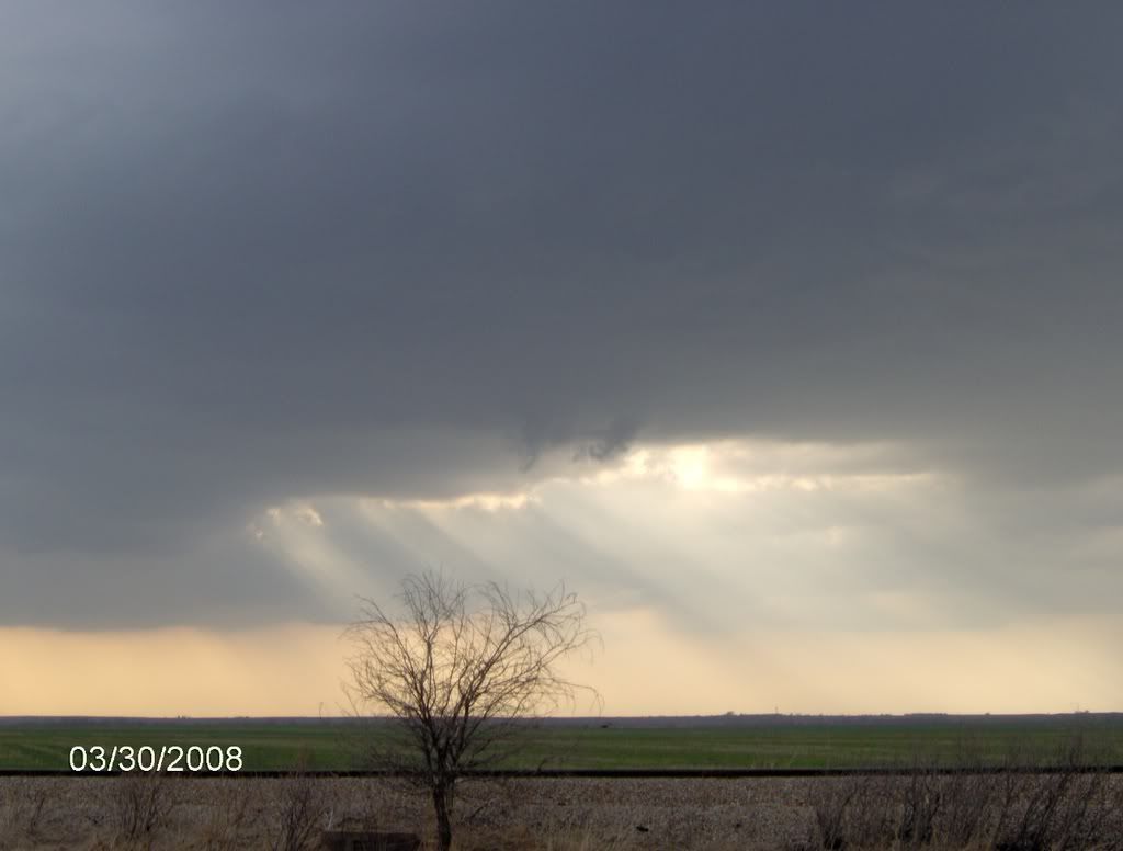 Great RFD shot W of Sentinel, OK. Most people would confuse this for a wall cloud but, it's just SLC (scary looking clouds) in the rear flank downdraft. 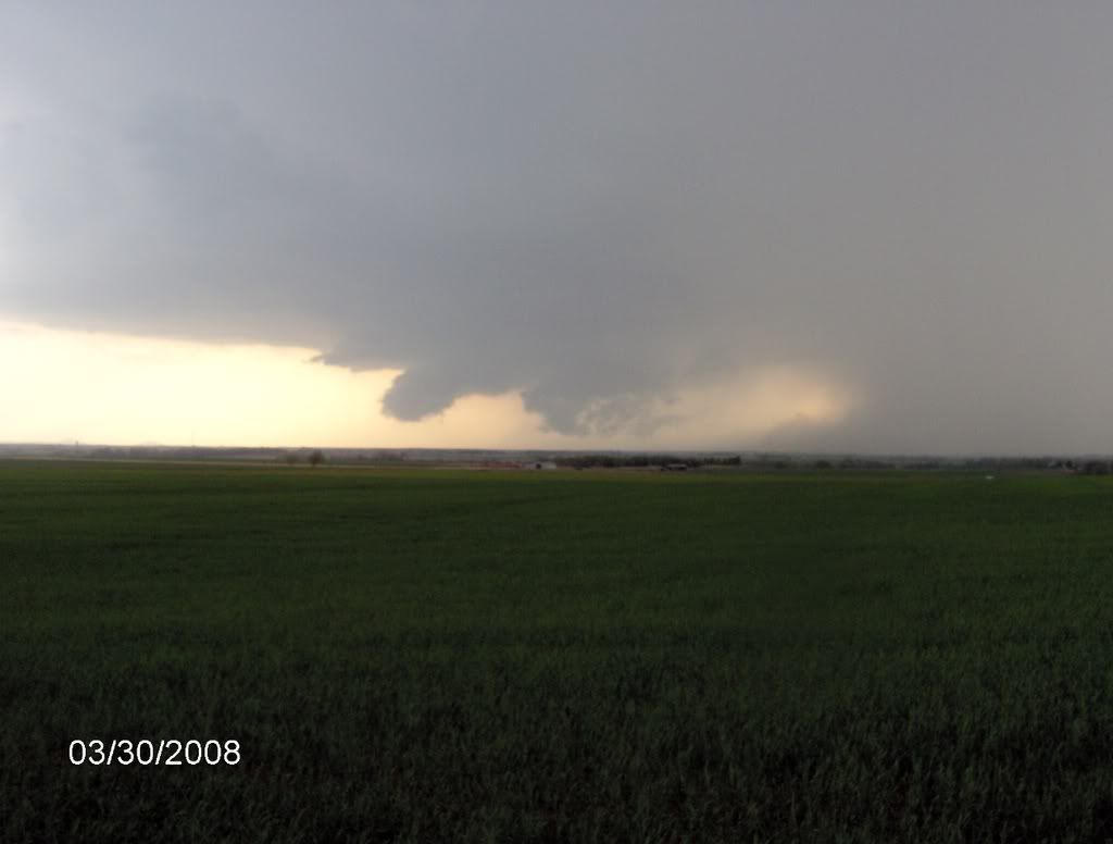 Awsome "Spaceship" structure. 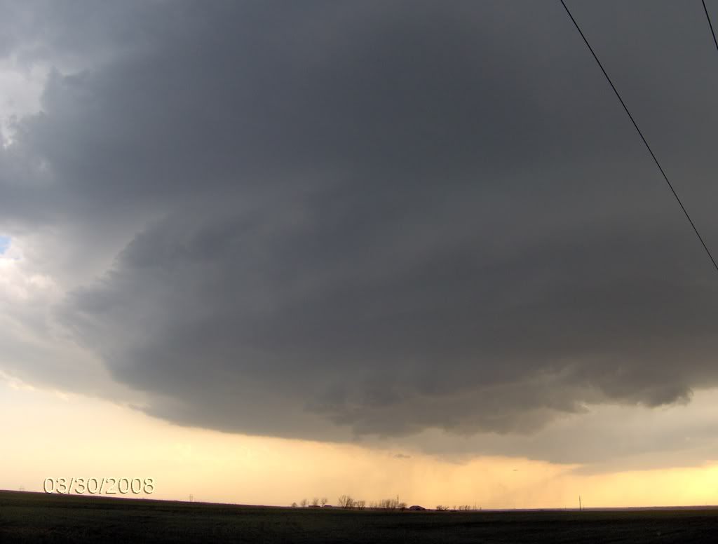 Elevated wall cloud ESE of Rocky, OK with more great "spaceship" structure.  We did get a tornado yesterday (3/31/08) in SE Oklahoma near Madill but, because of all the trees and hills, I have no pictures of the tornado. I just structure shots.
__________________
Spring time storm chaser, Year round Bass Angler!!! Largest bass; 6lbs 1oz., Length: 22" Girth: 15" |
|
|
|
|
04-01-08, 11:22 PM
|
#16 |
|
BassFishin.Com Premier Elite
Join Date: Feb 2006
Location: Webb City, MO
Posts: 6,387
|
great pictures!
__________________
You only live once. But if you do it right, once is enough. |
|
|
|
|
04-02-08, 01:47 PM
|
#17 |
|
BassFishin.Com Member

Join Date: Jan 2008
Location: Shelby,NC
Posts: 72
|
Great pics thanks man
__________________
*ProStaff for CB's Hawg Sacue *Owner of toneyoutdoors.com |
|
|
|
 |
|
Disclosure / Disclaimer
Before acting on the content posted, you should know that BassFishin.Com may benefit financially and otherwise from content, advertising, links or otherwise from anything you click on, read, or look at on our website. Click here to read our Disclosure Policy and Disclaimer. |
| Currently Active Users Viewing This Thread: 1 (0 members and 1 guests) | |
|
|


 Linear Mode

