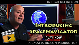


SpaceNavigator 3D Mouse For Virtual Exploration
In this video, Kevin shares with you a little-known device that will revolutionize how anglers use geospatial applications, like Google Earth and NASA World Wind. The 3dconnexion SpaceNavigator is a 3d mouse that let's you move around in three-dimensional space, like a helicopter, as you explore and do fishing reconnaissance. Kevin provides a full demonstration of SpaceNavigator and tells you why it is so important for bass fishermen. A must see!

Hey guys, Kevin Scarselli here.
I'd like to share with you a little-known product that will drastically improve the way you use geospatial applications like Google Earth and NASA World Wind.
Now many of you are familiar with our very in-depth Geospatial Advantage video, where we detail the many uses and tools available to anglers for fishing reconnaissance and virtual exploration. We are working on a sequel to The Geospatial Advantage, but there was one thing in particular that we felt was so important, that it deserved a video of its own, and we wanted to create that right away and get that out there for everybody.
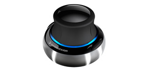
It's a product, called SpaceNavigator (by 3dconnexion). And it's what is called a 3d mouse. Again, it's called SpaceNavigator. And do you see this little, it's called a cap, at the top. It allows you to move around these geospatial applications (Google Earth, NASA World Wind, etc) in three-dimensional space. No more using the cumbersome keyboard and mouse to change your vantage point or your visual perspective. It is all now done with one hand, very easily, with the SpaceNavigator.
So let me give you a quick example of how it works and how you can use it to effectively use these geospatial applications. So here we are in Google Earth, at what is commonly termed, the "blue marble". I'm going to zoom into Ft. Washington Marina on the Potomac River. It just so happens to be a place I frequent a lot. So let me give you an example of how this works with one hand.
So I take the SpaceNavigator, and I'm just going to zoom right into Ft. Washington Marina. And there we are.
Now as you can see, it was very easy to drill down to a specific spot. What you can do with this turning cap at the top of the device is you can spin it, and that rotates your field of perspective. You can spin it right and left. You can also zoom it in and out by pressing the SpaceNavigator up and down.
You can pan left and right. Now what is really important is changing your field of perspective... the angle at which you view the earth. Right now we're at a top-down view, but with the 3d mouse you can change that to a more natural perspective, one that looks more familiar to you when you're out on the water.
Again, you can combine all these different axes of rotation and put them into a 3d movement. Almost like a helicopter. So let's do a little example here of how you can move around with SpaceNavigator.

- Review: Minn Kota vs. MotorGuide
- The Blog: Vintage Fishing Tackle Videos
- The Blog: Join Me In Standing Up Against...
- Review: Biography of Clay Dyer - Amazing!
- Review: Lazer Trokar Hooks: My Impressions
- Review: Suffer Eye Irritation From Boating?
- Video: SpaceNavigator For Geospatial Apps
- Video: The "Wiffle Spool" Trick
- Video: Setting Brake On Baitcasters
- Video: Preventing Twists On Spinning Reels
- The Blog: The Fishing Line Guide
- Video: The Geospatial Advantage
- Video: Baitcaster Backlash 'Thumb Trick'
- Store: Big Bass Zone
- Special: The BassFishin.Com Newsletter
- Video: How To Texas Rig A Bait